Built for OSP, Inside Plant, and Field Teams

Find the exact location of fiber breaks — on a map, in minutes.

Upload your OTDR .sor trace. We convert the fault distance into a GPS coordinate and street address, plotted on satellite imagery with your documented splice case locations. No guesswork. No wasted truck rolls.

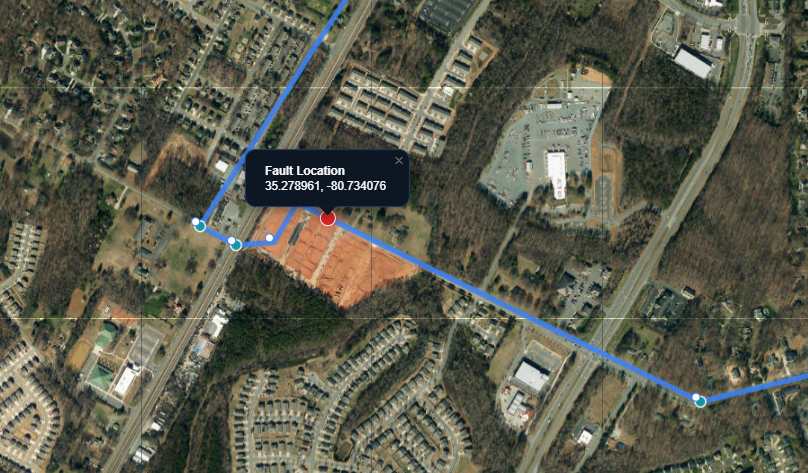
Fiber fault located on satellite map — Charlotte NC
~500 ft
Accuracy target
<60 sec
Fault location time
3 modes
Import options
99.999%
Uptime is the goal

Five nines means less than 5 minutes of downtime per year.

"99.999% uptime means less than 5 minutes of downtime per year. When fiber breaks, every minute spent driving to the wrong span is a minute toward a SLA breach. We built Optical Path Engineering to close that gap — giving your field technicians the street address of a fiber fault in the time it takes to read this sentence. And when the job is done, every splice case, device, and circuit your Inside Plant team touches lives in a structured hub and data center database — so the next crew knows exactly what's patched where."

Designed by engineers who have driven those wrong spans. Built for OSP crews, Inside Plant teams, and the field technicians who can't afford to do it twice.

The bridge nobody built

Two entire industries never talk to each other — and we built the thing that finally connects them.

OTDR Hardware

EXFO, VIAVI, AFL, and others build test equipment that measures the fiber and reports a distance to the fault. That's the whole job — the device has no idea where that number lands on a map.

GIS & OSS Platforms

Esri, IQGeo, OSPInsight, VETRO, and others document where your plant is supposed to be. None of them read a raw .sor trace file, and none take a field correction back from a tech at a splice case.

Fiber Damage Locator

Reads the number your OTDR already gives you, resolves it against whatever plant data you have, and writes clean, GPS-precise as-built data back into your system of record — in both directions.

This isn't a cheaper alternative to either category — every fault response and every splice case captured makes your underlying plant data more accurate. Built for daily use, not a specialty tool that sits idle between incidents.

Products

Two tools. One mission.

Whether you're responding to a fiber cut at 2 AM or building out documentation for a new hub, Optical Path Engineering gives your team the data precision to move faster.

📍

Fiber Damage Locator

Turn OTDR fault distance into a GPS address. Export from your internal mapping system (GIS, OSS, or network documentation platform), snap the route to roads, attach a .sor file, and get a map pin at the break — with a reverse-geocoded street address ready to hand to a field crew. Three import modes: mapping system export, GPS coordinates, or fully manual draw.

Learn more →
🏢

Facility Database System

Trace a circuit from headend device to customer — hop by hop, port by port — in seconds. Document facilities, racks, patch panels, preterm circuits, and cross-connects in a structured database that scales from a single cable hub all the way to a full data center. Know exactly what's patched where before you roll a truck. Auto-calc for power, HVAC, DC plant, generator, and rack power density.

Learn more →
New — Single User Tier

You have the OTDR.
Now you can actually use what it tells you.

Independent fiber contractors and subcontractors carry OTDRs every day. They can measure a fault down to 6.234 km. But without a GIS system, without a mapping platform, without an NOC behind them — that number is just a number. There's been no affordable software built for the tech in the field who works alone.

The Single User tier closes that gap — full Fiber Damage Locator, one person, one login.

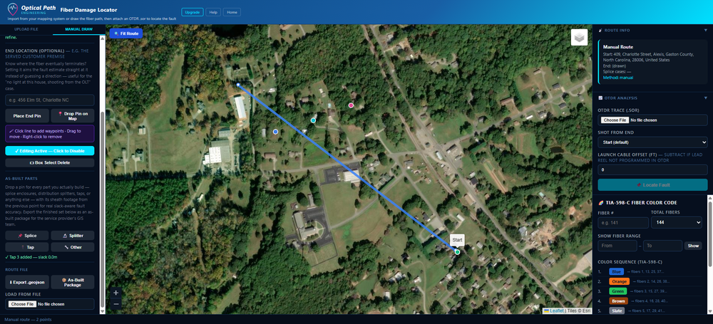
  • Draw the fiber route on the satellite map by clicking — no mapping system required
  • Upload your .sor file, click Locate Fault — get a GPS coordinate and street address
  • Export your routes as GeoJSON files and reload them on any future job
  • Build your own personal route library over time, one job at a time
See Single User pricing →
Single User
$29.99
/ month
$299/year — save 17%
Start Free Trial
1 user · 7-day free trial
No credit card required
New — As-Built Capture

You built it. Now proving it shouldn't be a second job.

Contractors don't just find faults — they build splice cases, splitters, and taps every day, then have to hand the service provider clean as-built records for their GIS. That's usually a separate, manual chore: a hand sketch, a spreadsheet typed up after the fact, GPS coordinates estimated from memory.

Manual Draw now doubles as an as-built capture tool. When the job's done, export one package — ready to hand over, not built by hand afterward.

  • Place splice enclosures, splitters, and taps at their real GPS coordinates as you build
  • Branch off any splitter or tap for real FTTx tree topology — not just a straight line
  • Attach the actual OTDR trace proving the loss at each splice, not just a number you remember
  • Export one package — CSV, Excel, GeoJSON, and a labeled PDF map — ready for the provider's GIS team
  • For BEAD-funded builds, doubles as the physical as-built record most state compliance plans require you to keep on file for five years
See how it works →
Splice, splitter, and tap parts placed along a drawn fiber route, each color-coded by type

From OTDR trace to GPS address in four steps.

1

Import the fiber route

Export splice case GPS coordinates from your internal GIS or network mapping system. Upload the spreadsheet or CSV — no special format needed.

2

Route auto-snaps to roads

Each span checks whether a road plausibly runs along the fiber's path — not just whether one exists nearby — before snapping. Otherwise it stays straight-line between splice cases.

3

Upload the .sor file

Drop in the OTDR trace. The fault distance is read automatically. Choose which end the trace was shot from.

4

Get the map pin

Click Locate Fault. A red pin drops at the fault GPS coordinate with the nearest street address — ready for dispatch.

Full walkthrough with screenshots →
Pricing — Fiber Damage Locator

Start free. Scale when you're ready.

Every plan includes a 7-day free trial — no credit card required. The Facility Database System is priced separately. See full pricing →

Single User
$29.99/ mo
$299/yr · 1 user · No mapping system needed
  • OTDR .sor fault location
  • Manual route draw
  • GeoJSON library export
  • PDF map export
Start Free Trial

The Facility Database System is priced separately by site — see full pricing page · Questions? Talk to us.

We come to your site.

Don't have your plant documented yet? Before the software can help, the data has to exist. We handle that for you.

What we do: We audit every hub, rack, port, and OCEF cabinet against your as-built documentation — including where each preterm connects to the outside plant fiber — and hand you a clean, importable data set. Facilities, racks, patch panels, circuits, preterm positions, DC plant — all mapped and loaded. Splice cases and other outside plant assets stay with your GIS system; this covers what's inside the facility. One-time engagement. Per-site pricing based on scope.

Who it's for: ISPs, cable headends, data centers, and IT teams with documentation in filing cabinets, spreadsheets, or nowhere at all. After an audit engagement, your team has a working Facility Database System they can maintain going forward.
Request Audit Pricing

Building toward deeper integration

We built this because OTDR hardware and GIS/OSS platforms were never designed to talk to each other — not because either one did anything wrong. We're actively working toward direct integration partnerships with OTDR manufacturers and GIS/OSS platforms, so this bridge eventually needs no manual export or upload step at all. If you build OTDR hardware or a GIS/OSS platform, we want to talk.

Get in Touch